Hare Catchment
≈163 km²
Catchment area used in the modern hydrological reconstruction.
Terrain data define the physical framework of the HARE watershed. The same DEM and drainage evidence are used to delineate the catchment, generate stream networks, derive slopes and subbasins, and provide geometric information for both HEC-HMS and SWAT.
Catchment area used in the modern hydrological reconstruction.
Used for watershed delineation, flow direction, drainage extraction, elevation and slope analysis.
The watershed outlet is defined at or near the Hare diversion headworks.
| Terrain layer | Purpose | HEC-HMS use | SWAT use |
|---|---|---|---|
| DEM | Defines elevation and topographic form of the watershed. | Supports basin delineation, slope and flow-path estimation. | Core input for watershed and stream delineation. |
| Watershed boundary | Defines the contributing catchment to the Hare outlet. | Basin area and hydrological model extent. | Watershed simulation boundary. |
| Stream network | Represents drainage pathways and river connectivity. | Supports routing and basin connectivity. | Defines reaches and subbasin drainage. |
| Subbasins | Divide the watershed into smaller hydrological units. | Can be used for basin subdivision and routing. | Fundamental SWAT watershed structure. |
| Slope | Describes terrain steepness and runoff response. | Supports time-of-concentration and runoff interpretation. | Used directly in HRU slope classification. |
| Flow direction / accumulation | Identifies drainage direction and concentrated flow paths. | Supports catchment and channel definition. | Used during automated watershed delineation. |
Terrain information is used to determine basin area, flow length, slope, drainage structure and routing geometry. These values support lag-time and time-of-concentration estimates used in rainfall-runoff modelling.
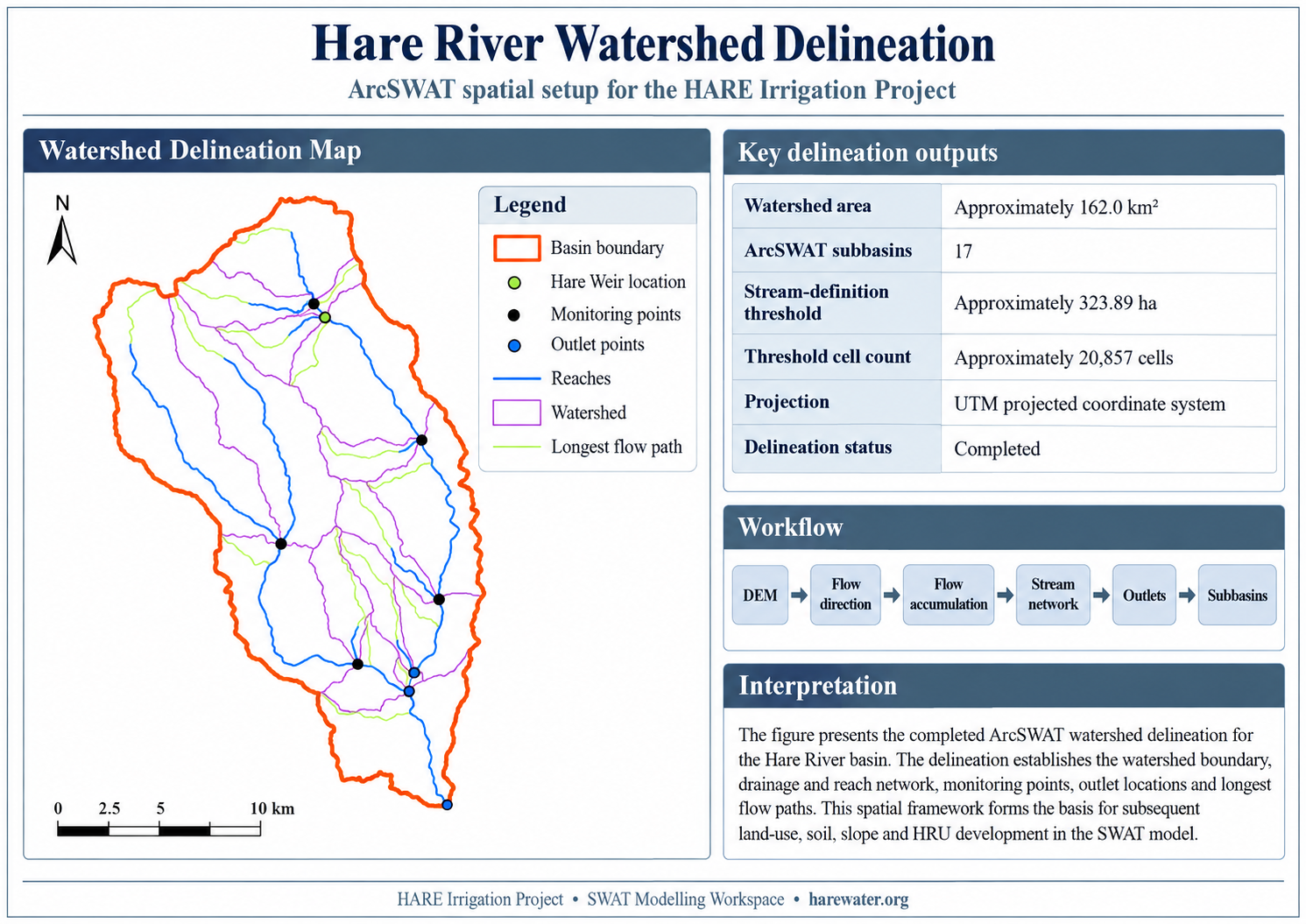
SWAT uses the DEM directly to delineate the watershed, streams, subbasins and outlet. The resulting terrain structure is later combined with land use, soils and slope bands to create HRUs.
CROPWAT does not require watershed terrain in the same way as HEC-HMS or SWAT. Terrain is nevertheless important for defining the irrigable command area, canal alignment, elevation differences and suitability of field irrigation.
The modern SWAT reconstruction used DEM-derived drainage to delineate the Hare watershed and identify the outlet associated with the project headworks. Stream generation, subbasin definition and slope derivation were completed before land-use and soil overlay and HRU creation.
| Check | Reason | Status |
|---|---|---|
| Projection | Ensure all terrain and model layers use a consistent projected coordinate system. | Checked |
| Watershed outlet | Confirm that the outlet corresponds to the Hare headworks / river control location. | Defined |
| Catchment area | Compare GIS-derived area with previous estimates and project records. | ≈163 km² |
| Stream alignment | Check DEM-derived drainage against mapped or satellite-observed river paths. | Visual review |
| Slope classification | Confirm slope ranges used in SWAT HRU generation. | Prepared |
| Command-area relation | Distinguish the upstream watershed from the lower irrigation command area. | Documenting |