The HARE
Project
A detailed 1995 irrigation-engineering study of the Hare River area near Arba Minch, preserving the original design logic for irrigation demand, hydrology, canals, regulators, diversion headworks and associated hydraulic infrastructure — now actively revisited through modern GIS, hydrological modelling and field evidence.
From River Hydrology to Irrigated Fields
The HARE Irrigation Project Design Report was completed in 1995 by Mesfin Hagos, Mitiku Bedru, Seid Shimelis and Tamir Mitiku as a Bachelor of Science in Engineering project at Arba Minch Water Technology Institute. At the time, the HARE irrigation scheme was already under construction by Chinese contractors. The student project therefore provided an exceptional opportunity to study, analyse and develop engineering calculations for a real irrigation scheme while its construction was taking place. The preserved report addresses the physical setting, irrigation-water quality, crop-water demand, hydrology, canal-system design, regulators, drops and diversion headworks.
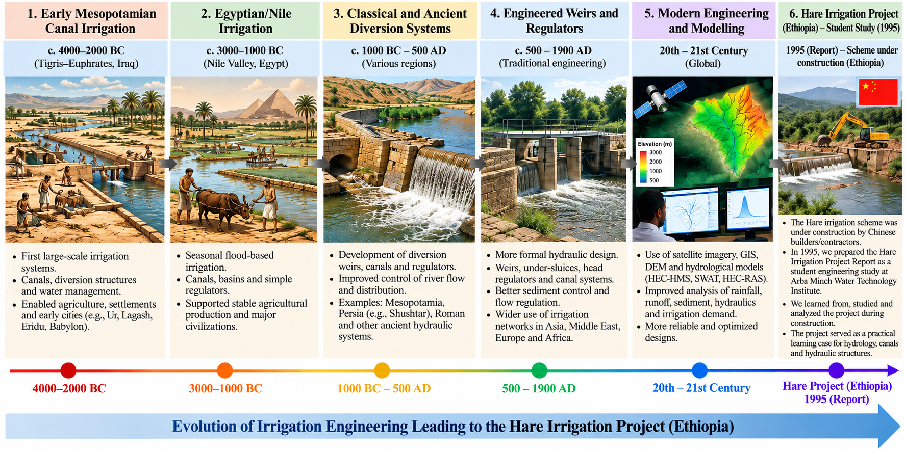
From Ancient Irrigation to the HARE Project
Irrigation engineering developed over thousands of years, from early gravity-fed canal systems in Mesopotamia and the Nile Valley to engineered diversion works, canal-control structures and today's GIS-based hydrological and hydraulic modelling.
A Site Considered Favorable for Surface Irrigation
The 1995 report describes the irrigation area as gently sloping terrain associated with an alluvial plain. The land rises and falls locally and includes small erosion gullies, but the overall topography was judged favorable for surface irrigation.
Hare River is described as originating in the Chencha Mountains at elevations above 3,000 m above mean sea level and flowing through gorges toward Lake Abaya. The report gives an average stream gradient of about 3.5 percent.
Engineering Scope of the 1995 HARE Project Report
The report progresses from the physical and agricultural basis of irrigation to the hydraulic structures needed to control and deliver water. The sections below summarize the main design domains preserved in the original study.
Project Setting
Geographical setting, geology, topography, soils, climate and the physical suitability of the Hare River command area for irrigation development.
Irrigation Water Quality
Assessment of sediment, dissolved salts, sodium, potentially toxic elements, bicarbonate, bacterial contamination, salinity and groundwater-management considerations.
Crop & Irrigation Demand
Crop-water requirements, effective rainfall, net and gross irrigation requirements, crop scheduling and diversion requirements using FAO-based procedures.
Hydrological Analysis
Analysis of Hare River flow records, annual peak flows, flood-frequency estimation and 1-in-5-year dry-period flows for design and water-availability assessment.
Canal System Design
Primary and secondary canals, field layout, tertiary drainage, canal capacity, permissible-velocity design and regime-theory comparison.
Regulators & Drops
Canal falls, distributary head regulators, cross regulators and related control structures for flow regulation, measurement, silt control and canal operation.
Diversion Headworks
Weir type and site selection, canal head regulator, under-sluice, divide wall, marginal bund and ancillary hydraulic works required to divert the Hare River.
Engineering Comparison
Comparison of calculated design results with information from the existing Hare irrigation works, including discharge, weir dimensions, canal layout and drop structures.
Designing for Floods, Dry Flows and Irrigation Demand
Hydrology was central to the original study because the diversion and canal system had to be considered against both flood risk and water availability. The report analysed Hare River flow records, momentary annual peak flows and dry-period flows, and estimated irrigation demand using crop-water requirements and effective rainfall.
Annual momentary peak-flow records were used in the flood-frequency work supporting hydraulic-structure design.
1-in-5 dry periodMonthly dry-period flows were analysed as part of the assessment of dependable water availability for irrigation.
FAO-based demandCrop evapotranspiration, effective rainfall and net/gross irrigation requirements formed the basis of crop and diversion-demand calculations.
Modern Hydrological Modelling Is Now Active
The modern reassessment has moved beyond planning. DEM-based watershed reconstruction, rainfall analysis, HEC-HMS design-flood modelling and SWAT continuous watershed modelling have now been completed to important intermediate stages and are being interpreted together with the original study and present field evidence.
Event-based rainfall-runoff modelling has been completed for the Hare Weir catchment. The revised IMERG 50-year event (75.62 mm in 24 hours) indicates an outlet peak of approximately 195.2 m³/s at Sink-1 / Hare Weir. This output is provisional until the revised HEC-HMS run is recomputed and confirmed. The earlier CHIRPS result was 114.4 m³/s.
Two runs completed SWATA continuous SWAT model has been developed for approximately 161.95 km² of watershed represented by 17 subbasins. Watershed delineation, HRUs, climate preparation and two successful simulations are complete.
Active interpretation SedimentSWAT Simulation 2 indicates an average upland sediment yield of approximately 58.4 Mg/ha and a strong modelled tendency toward channel deposition. Current field photographs independently show substantial gravel, sand and finer sediment accumulation at the diversion.
Canals, Regulators and Diversion Headworks
The original report compares two canal-design approaches: unlined sections based on regime theory and lined sections based on permissible-velocity criteria. The design process considers how silting and erosion affect canal capacity and full-supply depth.
Head regulators and cross regulators were treated as operating elements of the system rather than isolated structures. The report describes their roles in controlling off-taking discharges, measuring flow, reducing silt entry, maintaining upstream water levels during low flow, isolating canal reaches for repair and helping manage fluctuations in the network.
At the diversion, the original design scope includes the weir, canal head regulator, under-sluice, divide wall, marginal bund and associated works. The purpose of the headworks is to regulate river level and divert the required flow into the canal system, including during periods when natural river levels are low.
The modern reassessment adds a new emphasis on sediment management. Present field evidence shows substantial deposition around the diversion works, while SWAT indicates strong sediment generation in localized areas and substantial deposition within the modelled channel system.
Current design chain
- Hare River flow and flood assessment
- Weir and diversion-control concept
- Canal head regulator and under-sluice
- Scour and sediment-flushing requirements
- Sediment exclusion and desilting
- Main and secondary canal conveyance
- Cross regulators and distributary regulators
- Drop structures and turnouts
- Field delivery and drainage
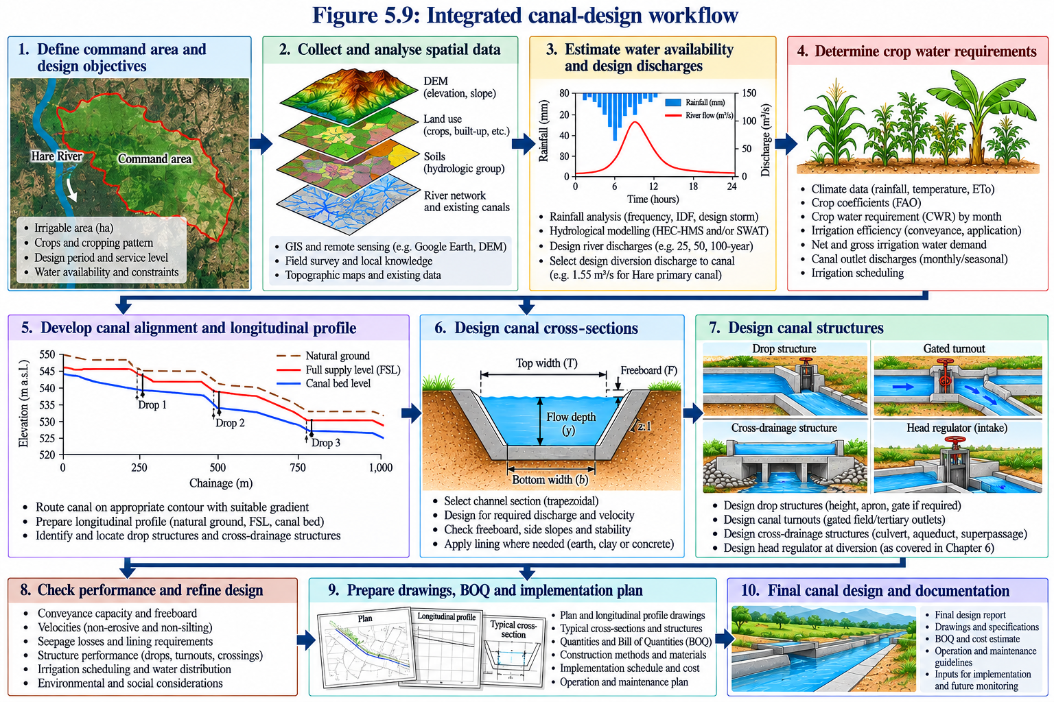
From Command Area to Final Drawings
This workflow summarizes the complete engineering sequence used to move from command-area definition, water availability and crop demand through canal alignment, hydraulic section design, structures, final drawings and the bill of quantities.
Past Calculations, Present Understanding
The original report remains preserved as a historical engineering document. The modern reassessment is maintained as a separate technical layer that reproduces, tests and reinterprets the earlier work using modern geospatial data, rainfall products, digital terrain, hydrological models and present-day field evidence while keeping the 1995 calculations visible for comparison.
Engineering with the Data and Methods Available Then
- Field reconnaissance and available topographic information
- Historical climate and river-flow records
- FAO crop-water estimation procedures
- Manual / tabulated hydrological-frequency analysis
- Regime-theory and permissible-velocity canal design
- Conventional hydraulic and structural calculations
- Comparison with information observed from the HARE irrigation works then under construction
Re-analysis with Modern Hydrology, GIS and Digital Terrain
- DEM-based catchment and terrain delineation
- GIS mapping of slope, drainage, land cover and command area
- Modern rainfall and hydroclimatic datasets
- Updated rainfall-frequency analysis
- HEC-HMS event-based design-flood modelling
- SWAT continuous watershed modelling
- Modern land-use and soil reconstruction
- Digital crop-water and irrigation-demand workflows
- Canal and drainage reconstruction
- Sediment-generation and channel-deposition assessment
- Field evidence from the present Hare diversion works
- Direct comparison of original and modern engineering decisions
Sediment Management from Catchment to Headworks
One of the strongest engineering findings emerging from HARE Revisited is that sediment should be considered throughout the watershed and diversion system rather than treated only as a maintenance problem at the weir.
Watershed source control
SWAT indicates strong spatial variability in sediment production, including localized bare-ground erosion hotspots. The modern assessment therefore supports targeted investigation of exposed ground, cultivated slopes and active gullies.
Potential catchment measures include bare-ground stabilization, contour cultivation, vegetative strips, terracing where slope and soil conditions justify it, gully rehabilitation and localized check structures.
Diversion-site control
Field observations show substantial gravel, sand and finer sediment accumulation around the existing Hare diversion works. Coarse sediment and bed load therefore need to be distinguished from finer suspended sediment.
Future headworks assessment should examine under-sluices or scour sluices, flushing routes, intake alignment, sediment exclusion, desilting facilities and routine operational sediment management.
An Engineering Project That Continued Beyond Graduation
HARE is valuable not only because of what was calculated in 1995, but because the project became an early engineering foundation for four professionals whose later careers developed across complementary parts of the water sector.
Four Engineers, One Shared Technical Beginning
The Digital Archive gives each engineer an individual professional record while preserving the HARE project as a collective work.
1995 to HARE Revisited
Original Design Report
While the HARE irrigation scheme was under construction by Chinese contractors, the four-member student team completed the HARE Irrigation Project Design Report as a Bachelor of Science in Engineering project at AWTI, using the real project as an engineering case study.
Professional Experience
The four engineers developed careers across irrigation, hydrology, dams, hydraulic engineering, WASH, wastewater, project leadership, government advisory work and digital water systems.
Digital Archive
The original project is preserved online together with Team1995 professional histories, the project book, maps, source material and the modern technical record.
HARE Revisited
Modern GIS, rainfall reconstruction, HEC-HMS and SWAT modelling are now being used to compare the original 1995 engineering decisions with present hydrological and water-resources practice.
Continue through the HARE Digital Archive
Explore the project book, Team1995, maps, GIS products, HEC-HMS design-flood analysis, SWAT watershed modelling and the continuing engineering reassessment.