Watershed
161.95 km²
Final ArcSWAT drainage area represented by 17 hydrologically connected subbasins.
The Hare River watershed was delineated in ArcSWAT using a digital elevation model and the ArcGIS Spatial Analyst hydrological-processing tools. The delineation established the drainage network, watershed boundary, outlets and subbasins required for subsequent land-use, soil, slope and Hydrologic Response Unit analysis.
The completed ArcSWAT delineation represents a watershed of approximately 161.95 km² and divides the basin into 17 hydrologically connected subbasins. This spatial framework has now been used successfully in continuous SWAT simulations of runoff, soil-water processes, evapotranspiration, groundwater contribution, streamflow and sediment transport.
| Component | Current SWAT Setup | Status |
|---|---|---|
| Digital Elevation Model | Project DEM prepared for ArcSWAT analysis | Completed |
| Projection | UTM projected coordinate system | Completed |
| Flow direction | Derived from the DEM | Completed |
| Flow accumulation | Derived from the DEM | Completed |
| Stream definition | ArcSWAT drainage-network generation | Completed |
| Stream threshold | Approximately 323.89 ha | Completed |
| Threshold cell count | Approximately 20,857 DEM cells | Completed |
| Watershed area | Approximately 161.95 km² | Completed |
| Subbasins | 17 SWAT subbasins | Completed |
| Outlet / drainage points | 17 delineation outlets associated with the hydrologically connected subbasin network | Completed |
| Subbasin parameters | Calculated by ArcSWAT | Completed |
| HRU analysis | Land use, soil and slope overlay completed | Completed |
| Weather input | NASA POWER daily climate data, 2020–2025, represented by 16 spatial weather points | Completed |
| Weather generator | Hare-specific weather-generator statistics prepared and successfully tested | Completed |
| SWAT input database tables | Required model input tables successfully generated and written | Completed |
| Continuous SWAT simulation | Daily simulations completed successfully for 2020–2025 | Completed |
| Model-output review | Hydrology, streamflow, water balance and sediment outputs under technical assessment | In progress |
Watershed delineation began with preparation of the project digital elevation model. The DEM provides the terrain surface from which ArcSWAT determines the direction and accumulation of surface drainage.
The DEM was processed within the projected UTM coordinate system so that distances, areas, slopes and drainage characteristics could be represented consistently throughout the watershed analysis.
From the DEM, ArcSWAT generated the terrain derivatives required for watershed delineation and stream-network development.
| Terrain Product | Purpose in Watershed Delineation |
|---|---|
| DEM | Represents the elevation surface of the Hare watershed. |
| Flow direction | Identifies the downslope direction of drainage from each DEM cell. |
| Flow accumulation | Calculates the number of upstream cells contributing drainage to each location. |
| Stream network | Identifies concentrated drainage paths once the selected accumulation threshold is exceeded. |
ArcSWAT converts the DEM-derived flow-accumulation surface into a drainage network by applying a minimum contributing-area threshold.
For the Hare watershed, the adopted stream-definition threshold was approximately:
323.89 ha
This corresponds to approximately:
20,857 DEM cells
Cells exceeding this contributing-area requirement were classified as part of the model drainage network.
The selected threshold controls the level of detail in the modelled stream system. A smaller threshold would generate additional tributaries and smaller subbasins, while a larger threshold would produce a more generalized drainage network.
The adopted value provided a practical representation of the Hare River drainage structure while retaining sufficient spatial detail for the subsequent SWAT analysis.
Following definition of the drainage network and outlets, ArcSWAT subdivided the Hare watershed into 17 hydrologically connected subbasins.
| Watershed Characteristic | SWAT Result |
|---|---|
| Total watershed area | Approximately 161.95 km² |
| Number of subbasins | 17 |
| Stream-definition threshold | 323.89 ha |
| Equivalent threshold cells | Approximately 20,857 cells |
| Subbasin parameters | Calculated by ArcSWAT |
| Current simulation status | Continuous SWAT runs completed |
Each subbasin represents a distinct drainage area contributing runoff to a particular segment of the modelled stream network.
This subdivision enables SWAT to represent spatial differences in terrain, land use, soil, slope and weather before routing water and sediment through the river system.
The completed watershed-delineation sequence can be summarized as:
DEM → Flow Direction → Flow Accumulation → Stream Network → Outlets → 17 Subbasins
ArcSWAT then calculated the physical parameters associated with each subbasin and prepared the spatial framework required for HRU generation.
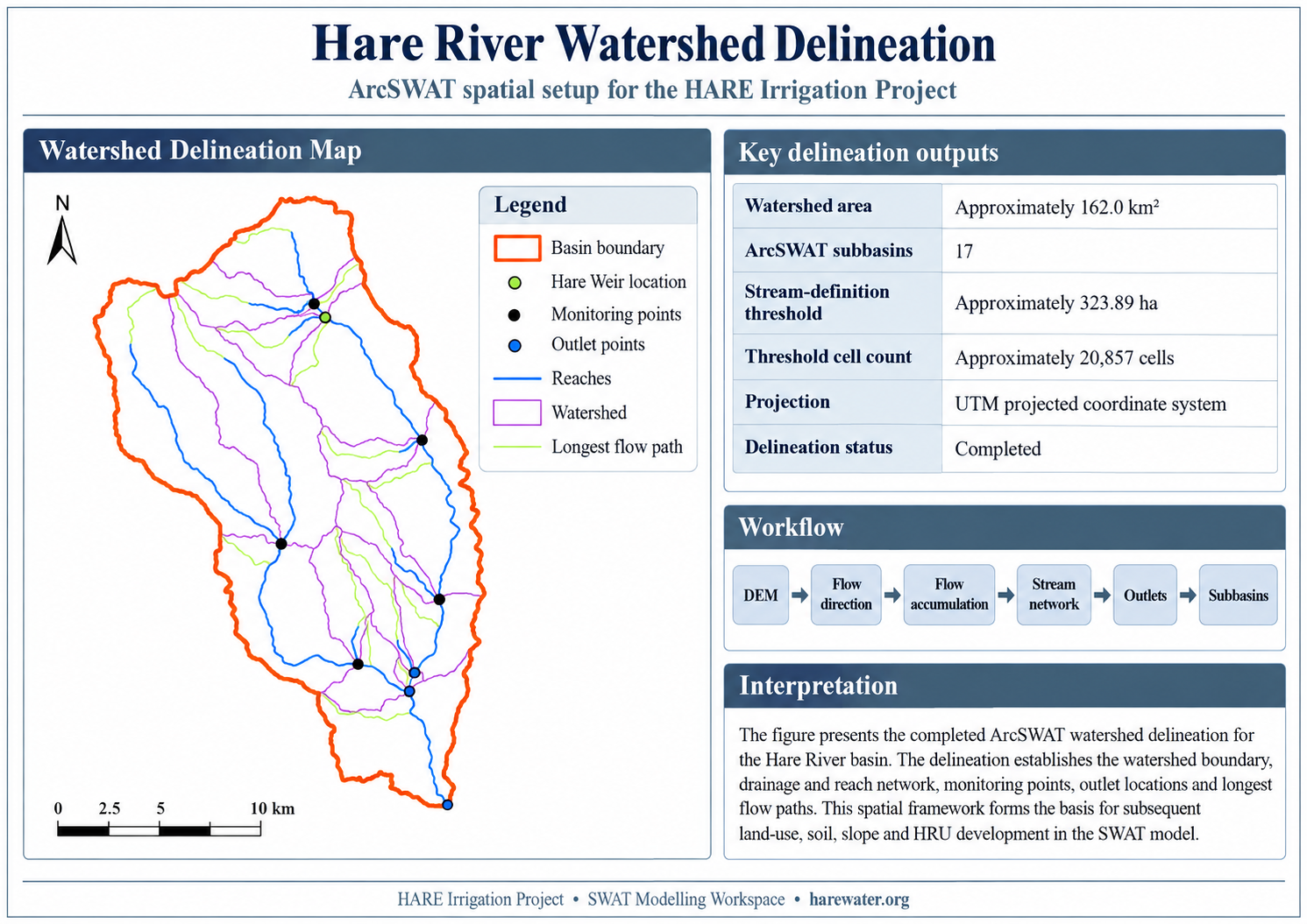
Hare River Watershed — ArcSWAT Watershed Delineation. The figure presents the completed ArcSWAT spatial setup for the Hare River watershed, including the watershed boundary, drainage and reach network, monitoring points, outlet locations, Hare Weir location and longest flow paths. The delineated watershed covers approximately 161.95 km² and provides the spatial framework for the 17-subbasin SWAT model. HRU development, climate-input preparation and continuous SWAT simulation have subsequently been completed.
Watershed delineation defines where water drains. HRU development then describes how different parts of those drainage areas respond to rainfall.
Within each of the 17 subbasins, ArcSWAT overlays the project land-use, soil and slope datasets. Unique combinations of these three spatial characteristics form Hydrologic Response Units.
Subbasin + Land Use + Soil + Slope → Hydrologic Response Units
The HARE model completed this stage using a Full HRU overlay and Multiple HRUs with zero-percent land-use, soil and slope elimination thresholds.
The resulting HRUs allow SWAT to represent variations in runoff, evapotranspiration, infiltration, soil-water processes and erosion within each subbasin.
The quality of a SWAT simulation depends fundamentally on correctly representing the drainage structure of the watershed.
The delineated stream network determines how runoff produced within the HRUs is transferred to subbasin channels and subsequently routed downstream.
Errors in watershed boundaries, stream location or subbasin configuration would therefore affect simulated runoff, streamflow, sediment transport and the overall watershed water balance.
The 17-subbasin configuration provides a spatially distributed framework for representing differences between the upper, middle and lower portions of the Hare watershed while maintaining a manageable model structure.
This framework has now successfully supported two continuous SWAT simulations and provides the basis for interpretation of daily flow, seasonal water balance, erosion and sediment-deposition behaviour.
The HARE hydrological reassessment uses HEC-HMS and SWAT for different but complementary purposes.
| Model | Watershed Configuration | Primary Role |
|---|---|---|
| HEC-HMS | Event-based catchment and routing model | Design-storm rainfall-runoff simulation and flood hydrograph estimation for the Hare diversion weir. |
| SWAT | 17-subbasin continuous watershed model with HRUs | Continuous watershed water balance, runoff, evapotranspiration, soil-water processes, groundwater, streamflow, erosion, sediment generation and channel sediment routing. |
The two models therefore provide complementary lines of hydrological evidence. HEC-HMS focuses on event-based design-flood behaviour at the Hare diversion weir, while SWAT describes continuous watershed response, seasonal water balance, daily river flow and sediment processes.
The models should not be expected to reproduce identical peak-discharge values because they represent different temporal scales and modelling approaches. Their results are instead interpreted together as part of the hydrological reassessment of the Hare Irrigation Project.
Watershed delineation is now complete and the 17-subbasin spatial framework has successfully progressed through HRU definition, climate-input preparation, SWAT database generation and continuous simulation.
161.95 km²
Final ArcSWAT drainage area represented by 17 hydrologically connected subbasins.
2020–2025
Daily NASA POWER precipitation, temperature, solar radiation, relative humidity and wind data supplied through 16 spatial weather points.
Successful
Daily continuous SWAT simulations completed and imported for hydrological and sediment assessment.
View the SWAT climate-input preparation | View the SWAT Hydrologic Response Unit analysis